
Hiking the Alps: To the Top of Schilthorn
This year, a friend of mine and I decided we wanted to summit our region’s three major peaks: Jungfrau, Monch, and Eiger.
Unfortunately, some unexpected financial barriers (to the tune of thousands of dollars) kept us from doing so. And so I adjusted my expectations, promised myself I’d tackle those peaks someday in the future, and set my sights a little lower for this year, deciding to tackle a mountain peak that wouldn’t require mountain guides or specialized gear, but would take me above the tree-line and give me a 360 degree view of the high Alpine scenery.
What is this magical, not-overly-high-but-still-challenging hike?
Schilthorn—a peak so lovely that the 1969 James Bond film chose it as a filming location.
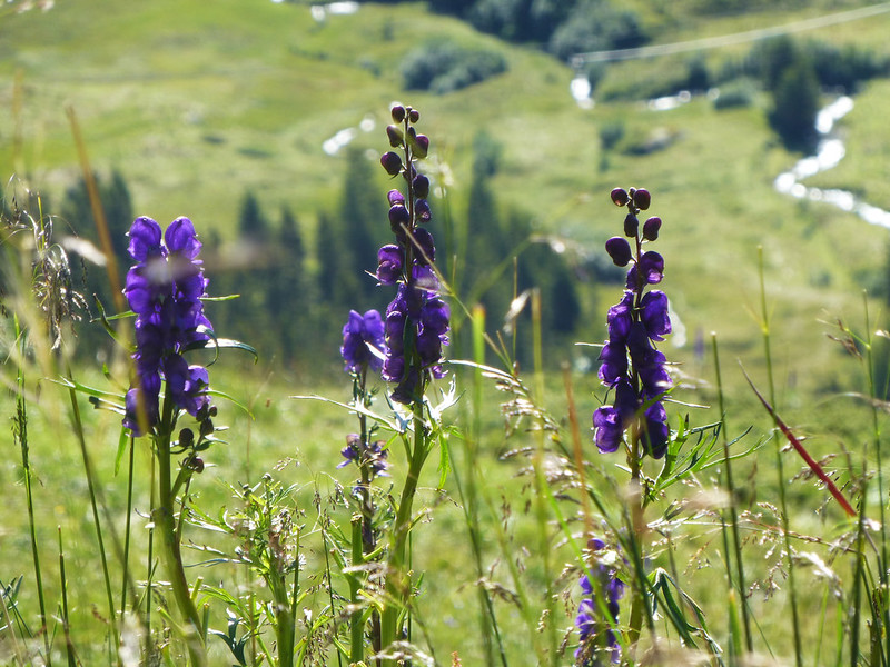
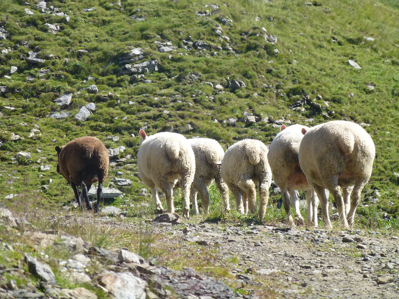
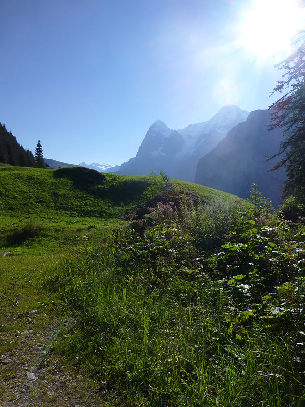
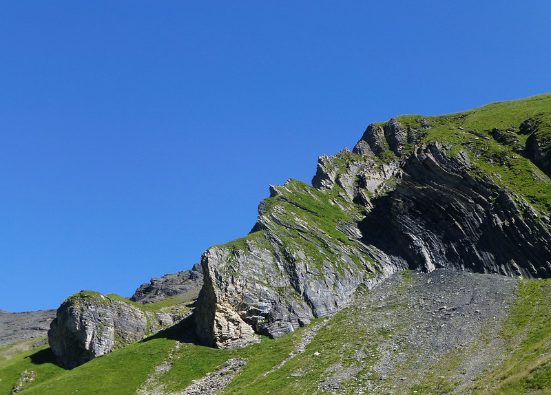
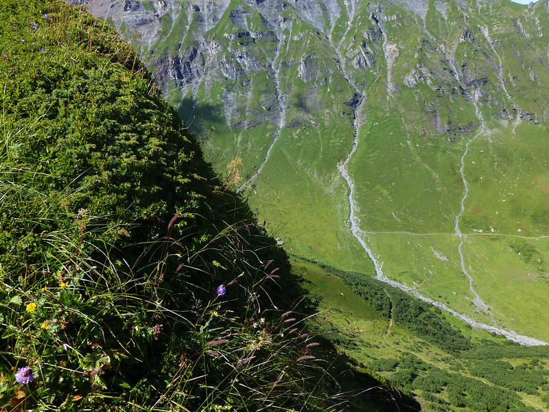
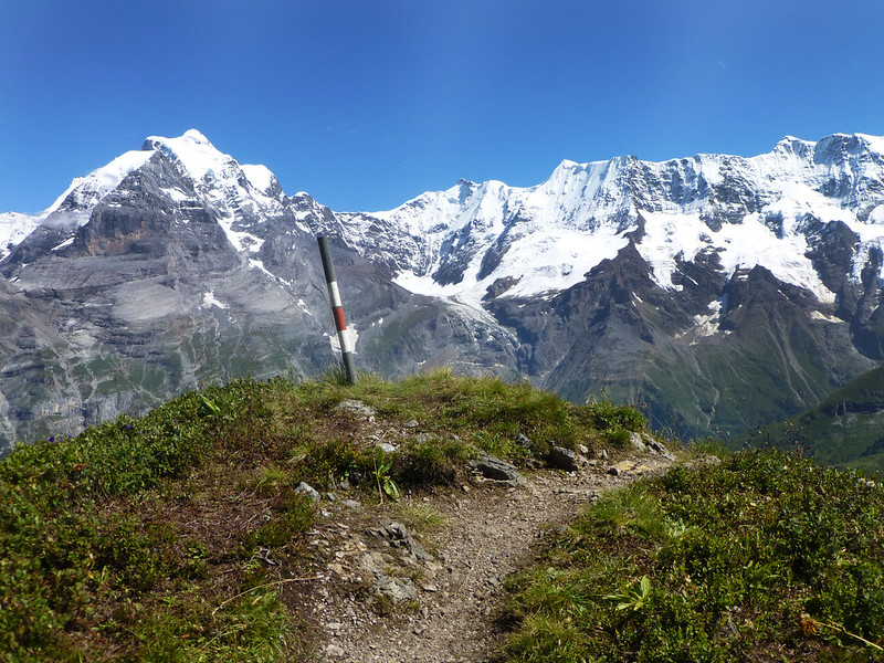
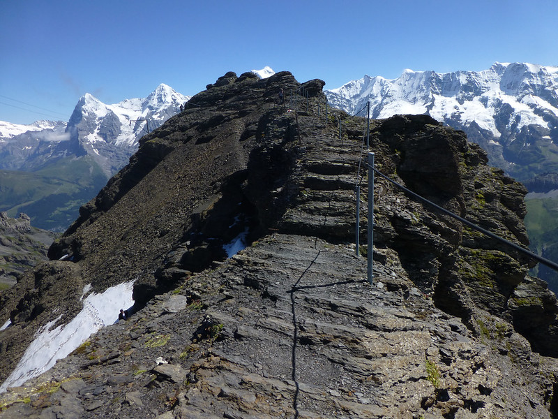
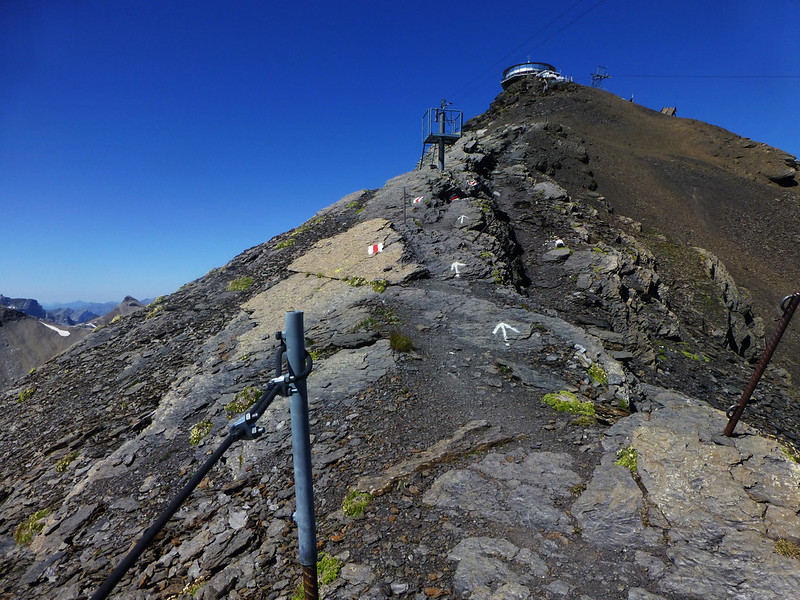
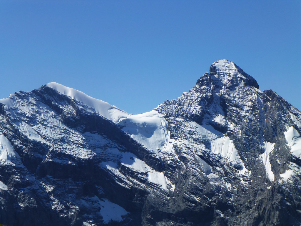
The hike itself is about five hours long, mostly steep, and incredibly beautiful, winding through woods and grassy ridges, over rock falls and past green-blue Alpine lakes with thin layers of silt that burst into clouds in the water as you wade in, and, of course, a rocky, above-the-treeline portion with views of the highest peaks for miles around.
Ironically, my failure to meet my original goal is exactly what introduced me to what is now my absolute favorite Bernese Oberland hike.
But enough talk. Here are some photos (scroll down for directions to duplicate the hike yourself).
Want to hike Schilthorn? If you’re starting from Murren, ignore the Schilthorn hiking signs (they’ll take you up, but the route they follow is far less beautiful than this lesser-known one) and, instead, walk to the cable car station (not the train station) and follow signs for the rotstockhutte. Partway to the hutte (hut), you’ll see signs for Bryndli: start following those. Then, as soon as you see signs for Schiltalp, follow those. Finally, you’ll come to a point where the Schiltalp sign points one way and a sign for Birg points another; follow the signs for Birg and keep beside the fence when the path splits. Keep following to Birg and then follow signs for Schilthorn.
Keep in mind that this hike is advanced, steep, and not for the faint of heart or the inexperienced (you’ll be crossing some ridges with dizzying drop-offs, a number of loose rock falls, and one extremely steep hillside where a wrong step could mean a long fall).
Hiking time is around five hours (longer if you mosey and take lots of photos). Elevation gain is 1,320 meters.
For you pros out there, if you want to make the hike even tougher, you can start from Lauterbrunnen and hike to Murren before starting the route described above. That steep, mostly forested hike adds about two hours and will take you over waterfalls, through thick, green woodlands, and past one of the region’s best panoramas.
Going to Switzerland? My full-sized Switzerland guide (with 100 local interviews) just published! Get your copy now.
All photos taken with my lovely little Lumix.
Comments
-
-
gigigriffis
One way. And you can either hike back down or cable car it.
-
-
Laura
Beautiful photos – this has been on my list since 1981 – time to do it!!
-
gigigriffis
Thanks!
-
-
Leah
Just bought and read your Switzerland book. Love it, and learned some things, and added to my itinerary (will be there in July). Quick question, what does “gruessech” translate to? hello? good day? Several people in the book suggested that as a greeting.
Also, if you had the choice of the via feratta in Murren or paragliding, which would you consider a must do?-
gigigriffis
So glad you liked it! I haven’t done the via feratta myself, but I loved paragliding over the valley. I’m sure either one will be spectacular, though.
Grussech is essentially the Swiss German hello in the Bernese Oberland (in Zurich, it’s gruezi, and you might come across other variations elsewhere).
-
-
Joe
Hi!
I think I am going to do this hike this coming Sunday. Can I ask: how do I get from the Murren train station to the cable car station? Is it easy to find?
Thank you!
-
gigigriffis
It’s super easy. Just follow the main road along the cliffs (out the train station to the left and keep left along that road) and you’ll eventually come to it. If you feel nervous, just ask a local. 🙂
-
-
tim heath
how much would a cable car be one way?
-
gigigriffis
I don’t know off the top of my head, but you should be able to check current pricing on the Swiss rail website.
-
-
Nita
Thank you for posting this. We also did this hike but was not able to take photos. It really took me back looking at your photos 🙂
-
Jen
Just a tip. My fiance and I were there in late June, the trail to the summit was not open and was still snow covered. We have done a bit of hiking on the snow before, but it was steep and when we asked about it, we were laughed at. Be aware that snow melts late up there and late June is still too early to attempt it.
We ended up modifying our plans.
-
gigigriffis
Good point. For high-altitude hiking, it’s best to plan on July, August (best option), or early September (sometimes).
-
-
Leo
Thanks for sharing this. I did this hike today and it was wonderful. Unfortunately it got pretty cloudy and the visibility was terrible by the time I got to the top. Just a heads up to anyone else thinking about doing this, I was charged 61 francs to take the gondola back down after I got up there. It ain’t cheap, and I didn’t get to take in the views because of the cloud cover.
-
gigigriffis
Sorry to hear that! And yes, weather conditions in the Alps (especially that high up) can change on a dime. For those who want to avoid the gondola fee or make it more manageable, I believe there are passes you can buy that include the high altitude gondola journeys (though don’t quote me on that). I’d look into Swiss Pass options and/or a Half-Fare Card and see if the high gondolas are included and if the price might be worth it for your stay, depending on how many trains and gondolas you plan on taking.
-
-
ian
hi gigi.this hike looks great and am thinking of flying over to try it in the next couple of weeks.i’ve only gotten into hiking this past year in the uk,ive climbed a few in the lake district and the 3 peaks.
i dont want to go in over my head and get caught out,so is this route one you would reccomend for someone relatively inexperienced,also is there any equipment i would require to achieve the ascent ?
thanks in advance for any advice-
gigigriffis
In a couple weeks, the weather conditions might not permit a full hike (unless you have snow/ice gear), so you may want to save this for next summer (best bet for hiking conditions is generally August, though July if often good and early September can be (I did one of my hikes to the top on Sept 8/9). You can reach out to the tourist office in Murren or Lauterbrunnen to ask about conditions and their recommendations – if it’s a mild weather year, you might still be okay in a couple weeks. But definitely ask.
I don’t think experience level matters much, but fitness is important – it’s a challenging hike for sure and you’ll be doing part of it in high altitude conditions. I always carry extra water, food, and cold-weather/rain gear. The tourist office may have more suggestions.
-
-
George Carewe
A group of us (7) just completed this hike in September of 2018. Just make sure you get to the restaurant facility on top by 6:00, they close up and this is the last cable car down. We arrived at 5:50. The weather closed in on us this day, never rained, but was cloudy and visibility was not much. Not too sure this was not a bad thing, might have scared me more if I was able to see what was around us and not concentrating on the trail. Tough hike from Rostockshutte up accross the ridge and through the rocks etc. Felt really good to have completed the hike.
Rob
Lovely. 5 hours round trip or 5 hours one-way?