
Hiking the Alps: Lauterbrunnen – Stechelberg – Gimmelwald – Mürren
No matter how much exploring I do around Switzerland, I always find myself back in the Bernese Oberland, hiking my heart out. There’s just something special about the landscapes here. The way they transition over and over again from fields of wildflowers to villages full of chalets, from steep waterfall-laden cliffs to cool, shaded forest trails, from precarious ridges to deep blue mountain lakes.
And so it’s no surprise that for our first longer hike of the summer, Chad and I again found ourselves on a series of trains out to Lauterbrunnen, the valley known for its 72 waterfalls.
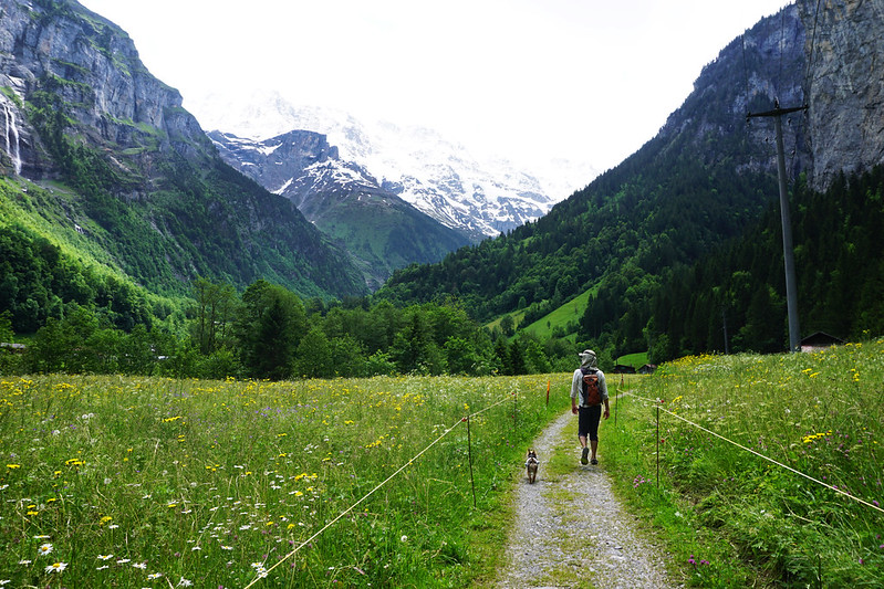
From there, we hiked along the valley floor to Stechelberg – an easy hike with little elevation gain and plenty of sweeping views of snow-capped peaks towering over sheer cliffs with waterfall after waterfall tumbling downward.
Along the way, you’re likely to see BASE jumpers coming off the cliffs, paragliders sweeping along high above, and plenty of cows and sheep grazing while the bells around their necks clang.


(Psst, this post may contain affiliate links, which means if you purchase something through one of my links, I get a commission at no extra cost to you.)
As you make your way toward Stechelberg, the path splits. Signs to the left point toward the town itself. Signs to the right lead upward into the mountains toward Gimmelwald, a town famously beloved by Rick Steves.
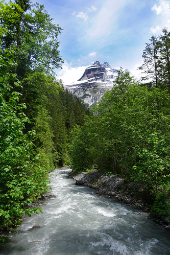
We turned to the right to make our way toward Gimmelwald – a path that leads through cool, shaded forest, past rushing rivers (most of which turn into the waterfalls you admired on the way here), and up a steep dirt track until it spills you out into open fields with views across the valley to snow-capped mountains.


As we emerged into Gimmelwald – a charming mountain village with a handful of restaurants, a hostel, and sweeping views – we continued following the trail markers, this time toward Mürren.
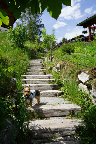
The track between Gimmelwald and Mürren is much more popular. It’s mostly paved and sometimes follows series of well-kept staircases. Along the way, signs (with English translations) educate hikers on the area’s avalanches and the forests and technologies that keep the Swiss safe here.
The route is easier than the Stechelberg to Gimmelwald trek and much more popular, so we were never really alone on it the way we were on the way up.
Still, it’s a beautiful walk.


When we arrived in Mürren, we made our way to the train station and back down to the valley via trains and cable cars.
If you’re planning to take on this hike yourself, here are the relevant details:
Hiking times and local transportation
The trek from Lauterbrunnen to Stechelberg takes 1 – 2 hours. Stechelberg to Gimmelwald adds another two hours (more if you’re taking your time; less if you’re a trail runner). And Gimmelwald to Mürren takes another hour. So plan on 4 – 6 hours total hiking time.
And if you only want to do one or two stretches of the hike? No problem. Each town has transportation to the other towns. You can take a bus from Stechelberg back to Lauterbrunnen (it should run every 30 minutes or so). You can take a cable car from Gimmelwald to Mürren or back down to the valley floor. From Mürren, a train and cable car ride will take you back to Lauterbrunnen or you can choose a cable car (at another station) down to Stechelberg.
Trail markers
Trails are well marked. Just follow the signs from Lauterbrunnen to Stechelberg and once you get near Stechelberg, start following signs for Gimmelwald and then Mürren.
Dogs on trails
Dogs are welcome on Swiss trails. Make sure you clean up after yours and keep them on a leash if they’re prone to running off after cows, sheep, or wildlife. The cows look friendly, but they will be happy to charge the crap out of your dog if the dog isn’t being mellow.
What to bring
The upward portion of the hike starting in Stechelberg is steep and can sometimes be muddy. Wear good hiking or trail running shoes (I like Salomon women’s speedcross).
Mountain weather can change quickly and be colder than you’d expect on a summer’s day. It’s always a good idea to have a jacket, even for a summer hike. I also carry a poncho if there’s any chance of rain.
Don’t forget to load up on water. Especially for hiking on a hot day. You’ll find a water fill-up fountain (a trough with running water coming out of a faucet above it) about 30 minutes outside Lauterbrunnen on the trail (it’s to the left of the trail under a tree where the trail splits off toward Trummelbach Falls). There’s another when you emerge from the forest alongside a couple Swiss chalets just below Gimmelwald (watch for it beside one of the first farmhouses you pass on the right). And there are more once you get into Mürren.
Since I’m hiking with a middle-aged small dog and occasionally she’s had some knee issues, I also hike with a dog backpack. Here’s the one I’ve been trying out (and like so far).
Happy hiking!
All photos taken with my Sony a6000.
Comments
-
-
gigigriffis
Thank you!
-
-
Annette Woods
Wow! Beautiful photos! Thank you for all the information, so detailed! What camera did you use to take those pictures? Or was it a phone camera?
-
gigigriffis
I use a Sony a6000. 🙂 Thanks!
-
Paula Elliott
I am GREEN with envy. Despite living there and having made many trips of my own, your photos far surpass my entire collection of 4 years. Just stunning. Very informative (and accurate, if anyone is wondering). Thanks for sharing!